Denali Park, Alaska (census-designated place)
Denali Park, Alaska | |
|---|---|
 Location in Denali Borough and the state of Alaska. | |
| Coordinates: 63°39′5″N 148°49′20″W / 63.65139°N 148.82222°W | |
| Country | United States |
| State | Alaska |
| Borough | Denali |
| Government | |
| • Borough mayor | Clay Walker[1] |
| • State senator | Click Bishop (R) |
| • State rep. | Dave Talerico (R) |
| Area | |
| • Total | 176.5 sq mi (457.2 km2) |
| • Land | 176.3 sq mi (456.6 km2) |
| • Water | 0.2 sq mi (0.6 km2) |
| Elevation | 1,749 ft (533 m) |
| Population (2010) | |
| • Total | 185 |
| • Density | 1/sq mi (0.4/km2) |
| Time zone | UTC-9 (Alaska (AKST)) |
| • Summer (DST) | UTC-8 (AKDT) |
| Area code(s) | 907 |
| FIPS code | 02-18805 |
| GNIS feature ID | 1423625 |
Denali Park, formerly McKinley Park, is a census-designated place (CDP) in Denali Borough, in the U.S. state of Alaska. As of the 2010 census, the population of the CDP was 185,[2] up from 142 at the 2000 census.
Geography[edit]


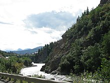
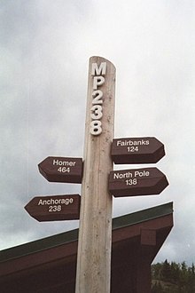
Denali Park is located at 63°39′5″N 148°49′20″W / 63.65139°N 148.82222°W (63.651444, -148.822322).[3] It is in the valley of the Nenana River along the eastern edge of Denali National Park and Preserve. The park's main visitor center is located along the main road into the park, just to the west of the CDP's limits. The George Parks Highway (Alaska Route 3) is the main road through the CDP: Anchorage is 231 miles (372 km) to the south, and Fairbanks is 128 miles (206 km) to the north.
According to the United States Census Bureau, the Denali Park CDP has a total area of 176.5 square miles (457.2 km2), of which 176.3 square miles (456.6 km2) is land and 0.2 square miles (0.6 km2), or 0.14%, is water.[2]
Climate[edit]
Denali Park has a subarctic climate (Dfc) like most of Alaska. Summer days are mild with nights being brisk. Winters are severely cold with extremely heavy annual snowfall averaging 79.5 inches (202 cm), with peak snow depth reaching 20 inches (50.8 cm) during March. Most of Denali Park's precipitation occurs during the months of June - September.[4]
| Climate data for Denali Park, Alaska | |||||||||||||
|---|---|---|---|---|---|---|---|---|---|---|---|---|---|
| Month | Jan | Feb | Mar | Apr | May | Jun | Jul | Aug | Sep | Oct | Nov | Dec | Year |
| Average high °F (°C) | 9.2 (−12.7) | 16.3 (−8.7) | 24.8 (−4.0) | 38.8 (3.8) | 53.6 (12.0) | 64.2 (17.9) | 66.3 (19.1) | 61.4 (16.3) | 50.7 (10.4) | 32.4 (0.2) | 17.3 (−8.2) | 11.2 (−11.6) | 37.2 (2.9) |
| Average low °F (°C) | −7.8 (−22.1) | −4.1 (−20.1) | 0.4 (−17.6) | 15.8 (−9.0) | 29.9 (−1.2) | 39.7 (4.3) | 43.4 (6.3) | 39.9 (4.4) | 30.6 (−0.8) | 14.5 (−9.7) | 0.9 (−17.3) | −5.6 (−20.9) | 16.5 (−8.6) |
| Average precipitation inches (mm) | 0.68 (17) | 0.60 (15) | 0.46 (12) | 0.37 (9.4) | 0.80 (20) | 2.32 (59) | 3.14 (80) | 2.57 (65) | 1.54 (39) | 0.92 (23) | 0.83 (21) | 0.90 (23) | 15.12 (384) |
| Average snowfall inches (cm) | 10.3 (26) | 10.2 (26) | 7.7 (20) | 5.1 (13) | 2.9 (7.4) | 0.3 (0.76) | 0.0 (0.0) | 0.0 (0.0) | 4.2 (11) | 12.3 (31) | 13.1 (33) | 13.4 (34) | 79.5 (202) |
| Source: Western Regional Climate Center[5] | |||||||||||||
Demographics[edit]
| Historical population | |||
|---|---|---|---|
| Census | Pop. | %± | |
| 1930 | 49 | — | |
| 1940 | 11 | −77.6% | |
| 1950 | 59 | 436.4% | |
| 1960 | 28 | −52.5% | |
| 1980 | 60 | — | |
| 1990 | 171 | 185.0% | |
| 2000 | 142 | −17.0% | |
| 2010 | 185 | 30.3% | |
| U.S. Decennial Census[6] | |||
Denali Park, then known as McKinley Park, first reported on the 1930 U.S. Census as an unincorporated village. It continued to report until 1960. It did not report in 1970. It has returned in every census since 1980, when it was made a census-designated place (CDP). With the restoration of the name of Mount McKinley to Denali made official in 2015, McKinley Park's name was changed to Denali Park.[7]
As of the census[8] of 2000, there were 142 people, 72 households, and 31 families residing in the CDP. The population density was 0.8 people per square mile (0.3/km2). There were 167 housing units at an average density of 1.0/sq mi (0.4/km2). The racial makeup of the CDP was 92.96% White, 0.70% Native American, 2.82% from other races, and 3.52% from two or more races. Hispanic or Latino of any race were 1.41% of the population.
There were 72 households, out of which 15.3% had children under the age of 18 living with them, 40.3% were married couples living together, 2.8% had a female householder with no husband present, and 55.6% were non-families. 41.7% of all households were made up of individuals, and 1.4% had someone living alone who was 65 years of age or older. The average household size was 1.97 and the average family size was 2.78.
In the CDP, the population was spread out, with 16.9% under the age of 18, 3.5% from 18 to 24, 43.0% from 25 to 44, 33.1% from 45 to 64, and 3.5% who were 65 years of age or older. The median age was 41 years. For every 100 females, there were 153.6 males. For every 100 females age 18 and over, there were 145.8 males.
The median income for a household in the CDP was $53,750, and the median income for a family was $64,583. Males had a median income of $56,250 versus $31,250 for females. The per capita income for the CDP was $27,255. About 8.6% of families and 11.5% of the population and 8.6% of families were below the poverty line, including 32.0% of those under the age of 18 and none of those 65 and older.
References[edit]
| Wikimedia Commons has media related to McKinley Park, Alaska. |
- ^ 2015 Alaska Municipal Officials Directory. Juneau: Alaska Municipal League. 2015. p. 5.
- ^ a b "Geographic Identifiers: 2010 Demographic Profile Data (G001): McKinley Park CDP, Alaska". U.S. Census Bureau, American Factfinder. Retrieved October 8, 2015.[dead link]
- ^ "US Gazetteer files: 2010, 2000, and 1990". United States Census Bureau. 2011-02-12. Retrieved 2011-04-23.
- ^ "MCKINLEY PARK, ALASKA - Climate Summary". wrcc.dri.edu. Retrieved 2020-06-10.
- ^ "McKinley Park, Alaska (505778) — Period of Record : 01/01/1923 to 04/30/2016". Western Regional Climate Center. Retrieved 25 January 2018.
- ^ "U.S. Decennial Census". Census.gov. Retrieved June 6, 2013.
- ^ http://live.laborstats.alaska.gov/pop/estimates/pub/chap4.pdf
- ^ "U.S. Census website". United States Census Bureau. Retrieved 2008-01-31.
Coordinates: 63°39′05″N 148°49′20″W / 63.651444°N 148.822322°W


No comments:
Post a Comment