South Floral Park, New York
South Floral Park, New York Jamaica Square | |
|---|---|
| Incorporated Village of South Floral Park | |
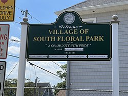
 A welcome sign at an entrance to the village on August 11, 2022. | |
| Nickname: SFP | |
| Motto: "A Community With Pride" | |
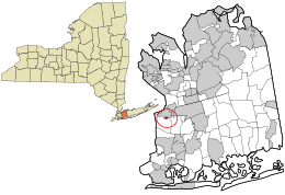
 Location in Nassau County and the state of New York | |
| Coordinates: 40°42′47″N 73°42′2″W / 40.71306°N 73.70056°WCoordinates: 40°42′47″N 73°42′2″W / 40.71306°N 73.70056°W | |
| Country | |
| State | |
| County | |
| Town | Hempstead |
| Incorporated | November 1925 |
| Named for | Its location south of Floral Park |
| Government | |
| • Mayor | Nyakya T. Brown |
| • Deputy Mayor | Jennifer Bellamy |
| Area | |
| • Total | 0.10 sq mi (0.25 km2) |
| • Land | 0.10 sq mi (0.25 km2) |
| • Water | 0.00 sq mi (0.00 km2) |
| Elevation | 69 ft (21 m) |
| Population (2020) | |
| • Total | 1,741 |
| • Density | 17,948.45/sq mi (6,910.87/km2) |
| Time zone | UTC-5 (Eastern (EST)) |
| • Summer (DST) | UTC-4 (EDT) |
| ZIP code | 11001 |
| Area code | 516 |
| FIPS code | 36-69023 |
| GNIS feature ID | 0965746 |
| Website | www |
South Floral Park (formerly known as Jamaica Square) is a village in the Town of Hempstead in Nassau County, on Long Island, in New York, United States. The population was 1,741 at the 2020 census.[2]
At 0.096 square miles (0.25 km2), the Incorporated Village of South Floral Park is the smallest village in the State of New York by total area.
History[edit]
The Village of South Floral Park was incorporated in November 1925 as the Village of Jamaica Square.[3] This name had been used since the area was first developed ca. 1905; the name was originally chosen so as to reflect the fact that it was down the road from Jamaica, Queens and next to Franklin Square.[3] However its name was changed to South Floral Park in 1931 due to confusion with said neighborhood in Queens; the new name was chosen based on the fact that the village is located immediately south of and adjacent to Floral Park.[3]
Residents decided to incorporate their community because they felt that the Town of Hempstead was unable to adequately fulfill the needs of their community, and believed that a more localized government would be able to govern it better.[3][4]
South Floral Park was one of the earliest racially integrated villages on Long Island.[3][4]
Geography[edit]
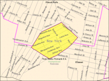
According to the United States Census Bureau, the village has a total area of 0.096 square miles (0.25 km2), all land.[5]
South Floral Park is the smallest village in the State of New York by total area.[6]
Climate[edit]
The Village of South Floral Park features a humid subtropical climate (Cfa) under the Köppen climate classification,.[7][8][9] As such, the village experiences hot, humid summers and cold winters, and experiences precipitation throughout the entirety of the year.[10]
Economy[edit]
The Village of South Floral Park is considered to be a bedroom community of the City of New York.[4]
The village itself is residential in character, consisting of a single residential zoning district which covers South Floral Park in its entirety.[11][12] As such, there are no areas zoned for commercial or industrial uses anywhere within South Floral Park.[11][12][13]
The majority of lots in the village consist of single-family residential homes, with the only major exception being the village hall and fire station complex.[4][11][12]
Demographics[edit]
| Historical population | |||
|---|---|---|---|
| Census | Pop. | %± | |
| 1930 | 460 | — | |
| 1940 | 510 | 10.9% | |
| 1950 | 572 | 12.2% | |
| 1960 | 1,090 | 90.6% | |
| 1970 | 1,032 | −5.3% | |
| 1980 | 1,490 | 44.4% | |
| 1990 | 1,478 | −0.8% | |
| 2000 | 1,578 | 6.8% | |
| 2010 | 1,764 | 11.8% | |
| 2020 | 1,741 | −1.3% | |
| U.S. Decennial Census[14] 2010[15] 2020[16] | |||
2020 census[edit]
| Race / Ethnicity | Pop 2010[15] | Pop 2020[16] | % 2010 | % 2020 |
|---|---|---|---|---|
| White alone (NH) | 245 | 158 | 13.89% | 9.08% |
| Black or African American alone (NH) | 971 | 834 | 55.05% | 47.90% |
| Native American or Alaska Native alone (NH) | 10 | 8 | 0.57% | 0.46% |
| Asian alone (NH) | 137 | 240 | 7.77% | 13.79% |
| Pacific Islander alone (NH) | 0 | 0 | 0.00% | 0.00% |
| Some Other Race alone (NH) | 20 | 27 | 1.13% | 1.55% |
| Mixed Race/Multi-Racial (NH) | 65 | 90 | 3.68% | 5.17% |
| Hispanic or Latino (any race) | 316 | 384 | 17.91% | 22.06% |
| Total | 1,764 | 1,741 | 100.00% | 100.00% |
Note: the US Census treats Hispanic/Latino as an ethnic category. This table excludes Latinos from the racial categories and assigns them to a separate category. Hispanics/Latinos can be of any race.
2000 Census[edit]
At the 2000 census there were 1,578 people, 456 households, and 383 families in the village. The population density was 15,776.3 people per square mile (6,092.7/km2). There were 462 housing units at an average density of 4,618.9 per square mile (1,783.8/km2). The racial makeup of the village was 22.18% White, 59.06% African American, 0.25% Native American, 3.80% Asian, 6.15% from other races, and 8.56% from two or more races. Hispanic or Latino of any race were 13.56%.[17]
Of the 456 households 35.3% had children under the age of 18 living with them, 54.8% were married couples living together, 22.1% had a female householder with no husband present, and 16.0% were non-families. 12.3% of households were one person and 5.9% were one person aged 65 or older. The average household size was 3.46 and the average family size was 3.72.
The age distribution was 26.7% under the age of 18, 7.9% from 18 to 24, 28.5% from 25 to 44, 25.0% from 45 to 64, and 11.9% 65 or older. The median age was 36 years. For every 100 females, there were 97.0 males. For every 100 females age 18 and over, there were 87.8 males.
The median household income was $64,205 and the median family income was $68,000. Males had a median income of $36,250 versus $37,292 for females. The per capita income for the village was $21,091. About 0.8% of families and 2.8% of the population were below the poverty line, including none of those under age 18 and 6.3% of those age 65 or over.
Government[edit]
As of August 2022, the Mayor of South Floral Park is Nyakya T. Brown, the Deputy Mayor is Jennifer Bellamy, and the Village Trustees are Jennifer Bellamy, LeRoy Graham, Jr., Randy Jaques, and Porscha Lyons.[18]
The South Floral Park Village Hall is located in the heart of the village, at 383 Roquette Ave.[18]
Education[edit]
South Floral Park, in its entirety, is located within the boundaries of (and is thus served by) the Elmont Union Free School District for elementary education and the Sewanhaka Central High School District for secondary education.[13] As such, all children who reside within the village and attend public schools go to school in one of these two districts, depending on what grade they are in.[13]
References[edit]
- ^ "ArcGIS REST Services Directory". United States Census Bureau. Retrieved September 20, 2022.
- ^ "South Floral Park village, New York". United States Census Bureau. Retrieved February 23, 2021.
- ^ a b c d e Winsche, Richard (October 1, 1999). The History of Nassau County Community Place-Names. Interlaken, New York: Empire State Books. pp. 94–95. ISBN 978-1557871541.
- ^ a b c d "History Of Our Village". The Incorporated Village of South Floral Park. Retrieved 2021-06-12.
- ^ "US Gazetteer files: 2010, 2000, and 1990". United States Census Bureau. 2011-02-12. Retrieved 2011-04-23.
- ^ "New York: 2010, Population and Housing Unit County, 2010 Census of Population and Housing (CPH-2-34)" (PDF). United States Census Bureau. June 2012. Retrieved January 9, 2013.
- ^ "Story Map Series: The Climate Zone World Map". arcgis.com. Retrieved 2020-11-07.
- ^ "Interactive United States Koppen-Geiger Climate Classification Map". plantmaps.com. Retrieved 2020-11-07.
- ^ "World Map of Köppen-Geiger Climate Classification". 2015-01-13. Archived from the original on 2015-01-13. Retrieved 2020-11-07.
- ^ "Humid subtropical climate | climatology". Encyclopedia Britannica. Retrieved 2020-11-07.
- ^ a b c "Village of South Floral Park, NY: Districts designated". Village of South Floral Park, NY Village Code. Retrieved 2022-08-11.
- ^ a b c "Village of South Floral Park, NY: Residence District Regulations". Village of South Floral Park, NY Village Code. Retrieved 2022-08-11.
- ^ a b c "Long Island Index: Interactive Map". www.longislandindexmaps.org. Retrieved 2022-08-12.
- ^ "Decennial Census of Population and Housing by Decades". US Census Bureau.
- ^ a b "P2 HISPANIC OR LATINO, AND NOT HISPANIC OR LATINO BY RACE - 2010: DEC Redistricting Data (PL 94-171) - South Floral Park village, New York". United States Census Bureau.
- ^ a b "P2 HISPANIC OR LATINO, AND NOT HISPANIC OR LATINO BY RACE - 2020: DEC Redistricting Data (PL 94-171) - South Floral Park village, New York". United States Census Bureau.
- ^ "U.S. Census website". United States Census Bureau. Retrieved 2008-01-31.
- ^ a b "Village Government". The Incorporated Village of South Floral Park. Retrieved 2021-06-12.


No comments:
Post a Comment