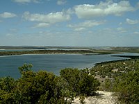
Coffin Bay National Park
This article needs additional citations for verification. (February 2014) (Learn how and when to remove this template message) |
| Coffin Bay National Park South Australia | |
|---|---|
 Avoid Bay, on the national park's west coast | |
| Nearest town or city | Coffin Bay |
| Coordinates | 34°40′25″S 135°25′48″E / 34.6737°S 135.4301°ECoordinates: 34°40′25″S 135°25′48″E / 34.6737°S 135.4301°E[1] |
| Established | 2 December 1982[2] |
| Area | 309.76 km2 (119.6 sq mi)[3] |
| Managing authorities | Department for Environment and Water |
| Website | Coffin Bay National Park |
| See also | Protected areas of South Australia |
Coffin Bay National Park is a protected area in on the Eyre Peninsula of South Australia, Australia, which is located about 301 km west of Adelaide and about 46 km west of Port Lincoln. The town of Coffin Bay is near the entrance to the national park. The national park occupies the Coffin Bay Peninsula - a long peninsula with a sheltered bay to its north, coastal dunes, swamps and a coastline which overlooks islands, reefs, limestone cliffs and white surf beaches.
To the east of Point Avoid are Almonta and Gunyah Beaches, used for surfing. Reefs extend out to sea from Point Avoid to Golden Island with Price Island further out. There is a camping area at Yangie Bay with camping fees payable on entry to the National Park. Access to the majority of the park's area north of Yangie Bay is via four wheel drive tracks only.
The historic former Coffin Bay Whaling Site at Point Sir Isaac lies within the national park and is listed on the South Australian Heritage Register.[4]
Contents
Wildlife[edit]
There is a great variety of wildlife in the national park. Many seabirds can be seen including white-bellied sea eagles and ospreys as well as various albatrosses and petrels.
The volunteer organisation Friends of Coffin Bay Parks have worked to re-introduce native plants and eradicate feral animals and weeds.
Associated protected areas[edit]
Statutory[edit]
The waters adjoining the coastline of the national park are within the Thorny Passage Marine Park.[5]
Non-statutory arrangements[edit]
The area covered by the national park is also overlapped by the Coffin Bay Important Bird Area, a non-statutory classification determined by BirdLife International. This particular IBA supports over 1% of the world populations of pied and sooty oystercatchers, as well as significant numbers of fairy terns, hooded plovers, western whipbirds, rock parrots and blue-breasted fairy-wrens.[6]
Gallery[edit]
See also[edit]
- Protected areas of South Australia
- Avoid Bay Islands Conservation Park
- Kellidie Bay Conservation Park
- Mount Dutton Bay Conservation Park
- Whidbey Isles Conservation Park
References[edit]
- ^ a b "Terrestrial Protected Areas of South Australia (refer 'DETAIL' tab )". CAPAD 2016. Australian Government, Department of the Environment (DoE). 2016. Retrieved 21 February 2018.
- ^ Slater, John W. (2 December 1982). "NATIONAL PARKS AND WILDLIFE ACT, 1972-1981: SECTIONS 28 AND 43—CROWN LANDS CONSTITUTED AS NATIONAL PARK—COFFIN BAY NATIONAL PARK—DECLARATION AS TO MINING RIGHTS" (PDF). The South Australian Government Gazette. Government of South Australia. p. 1750. Retrieved 14 February 2019.
Section 665, Hundred of Lake Wangary, County of Flinders.
- ^ "Protected Areas Information System - reserve list (as of 25 November 2014)" (PDF). Department of Environment Water and Natural Resources. Retrieved 8 January 2015.
- ^ "Former Coffin Bay Whaling Site (designated place of archaeological significance) Coffin Bay National Park". South Australian Heritage Register. Department of Environment, Water and Natural Resources. Retrieved 12 February 2016.[permanent dead link]
- ^ "MARINE PARK 5 Thorny Passage" (PDF). Department of Environment, Water and Natural Resources. Retrieved 4 February 2015.
- ^ "Important Bird Areas factsheet: Coffin Bay". BirdLife International. 2014. Retrieved 29 October 2014.


No comments:
Post a Comment