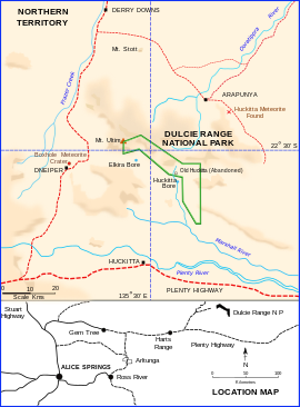
Dulcie Range National Park
| Dulcie Range National Park Northern Territory | |
|---|---|
 Dulcie Range National Park N.T. | |
| Nearest town or city | Alice Springs |
| Coordinates | 22°32′14″S 135°32′37″E / 22.5372°S 135.5436°ECoordinates: 22°32′14″S 135°32′37″E / 22.5372°S 135.5436°E[2] |
| Established | 1 March 1991[1] |
| Area | 191.12 km2 (73.8 sq mi)[1] |
| Managing authorities | Parks and Wildlife Commission of the Northern Territory |
| See also | Protected areas of the Northern Territory |
Dulcie Range is a national park in the Northern Territory of Australia, 220 km north-east of Alice Springs and 1235 km southeast of territorial capital of Darwin.[2][3] The park lies along the south-western edge of Dulcie Range. It was first declared in 1991 and again in July 2012.[4] A draft Plan of Management was published by the Parks and Wildlife Commission of the Northern Territory in May 2001.
Contents
History[edit]
The first recorded European visitor to the area was Charles Winnecke in 1878. In 1916 the chief surveyor of the Northern Territory, T. E. Day surveyed the range and named it Dulcie after one of his daughters. Around 1920 an early pastoral lease was taken out at Old Huckitta station, the remains of which are within the southern boundary of the park. There was an established population of traditional aboriginal Akarre Arrernte people, evidenced by numerous rock art sites in the Dulcie Range. A plentiful supply of food resources and water supported the clans. [5]
Description[edit]
The Range is a sandstone plateau standing from 50 to 150 metres above the surrounding plain in the Georgina Basin. Typical of the plains flora are mulga shrub-lands, mallee eucalypt, open woodland and spinifex. The plateau comprises steep sided cliffs, gorges and scree of the predominant Dulcie Sandstone, with numerous watercourses. Recorded in the park are 105 species of bird, 32 of reptiles, 2 of frogs and 3 of fish.[5]
See also[edit]
- Protected areas of the Northern Territory
- Horn Expedition led by C. Winnecke
- Huckitta (meteorite)
- Boxhole crater
References[edit]
- ^ a b c "CAPAD 2012 Northern Territory Summary (see 'DETAIL' tab)". CAPAD 2012. Australian Government - Department of the Environment. 7 February 2014. Retrieved 7 February 2014.
- ^ a b "Place Names Register Extract for "Dulcie Range National Park"". NT Place Names Register. Northern Territory Government. Retrieved 4 February 2020.
- ^ Hema, Maps (2005). Australia's Great Desert Tracks NE Sheet (Map). Eight Mile Plains Queensland: Hema Maps. ISBN 978-1865005461.
- ^ Hampton, Karl Rio (20 July 2012). "Territory Parks and Wildlife Conservation Act, REDECLARATION OF PARK" (PDF). Northern Territory Government Gazette. Northern Territory Government. Retrieved 4 February 2020.
- ^ a b "Dulcie Range National Park : draft plan of management". Parks and Wildlife Commission of the Northern Territory. 2001. Archived from the original on 25 September 2015. Retrieved 4 February 2020.
| This Northern Territory geography article is a stub. You can help Wikipedia by expanding it. |
| This Australian protected areas-related article is a stub. You can help Wikipedia by expanding it. |

No comments:
Post a Comment