Halderberge
Jump to navigation Jump to search

Halderberge | |
|---|---|
 Basilica in Oudenbosch | |
 Flag Coat of arms | |
.svg) Location in North Brabant | |
| Coordinates: 51°35′N 4°32′E / 51.583°N 4.533°ECoordinates: 51°35′N 4°32′E / 51.583°N 4.533°E | |
| Country | Netherlands |
| Province | North Brabant |
| Established | 1 January 1997[1] |
| Government | |
| • Body | Municipal council |
| • Mayor | Jobke Vonk-Vedder (CDA) |
| Area | |
| • Total | 75.21 km2 (29.04 sq mi) |
| • Land | 74.47 km2 (28.75 sq mi) |
| • Water | 0.74 km2 (0.29 sq mi) |
| Elevation | 3 m (10 ft) |
| Population (January 2019)[5] | |
| • Total | 30,194 |
| • Density | 405/km2 (1,050/sq mi) |
| Time zone | UTC+1 (CET) |
| • Summer (DST) | UTC+2 (CEST) |
| Postcode | 4730–4754 |
| Area code | 0165 |
| Website | www |
Halderberge (Dutch pronunciation: [ˈɦɑldərˌbɛrɣə] (![]() listen)) is a municipality in the southern Netherlands.
listen)) is a municipality in the southern Netherlands.
Population centres[edit]
- Oudenbosch (population: 13,110)
- Hoeven (6,560)
- Oud Gastel (6,360)
- Bosschenhoofd (2,180)
- Stampersgat (1,330)
Topography[edit]

Dutch Topographic map of the municipality of Halderberge, June 2015
Transportation[edit]
Railway Dordrecht to Roosendaal (part of line 11), with stations and official station abbreviations:
- Dordrecht (Ddr) (mun. Dordrecht)
- Dordrecht Zuid (Ddzd) (mun. Dordrecht)
- Lage Zwaluwe (Zlw) (mun. Moerdijk)
- Zevenbergen (Zvb) (mun. Moerdijk)
- Oudenbosch (Odb) (mun. Halderberge)
- Roosendaal (Rsd) (mun. Roosendaal)edit
International relations[edit]
Twin towns — Sister cities[edit]
Halderberge is twinned with:
Notable people[edit]

- Jac. van Ginneken (1877 in Oudenbosch - 1945) a Dutch linguist, Jesuit priest and academic
- Marinus Jan Granpré Molière (1883 in Oudenbosch — 1972) a Dutch architect
- Gabriel Nuchelmans (1922 in Oud Gastel – 1996) a Dutch philosopher, focused on the philosophy of the Middle Ages
- Cretien van Campen (born 1963 in Oudenbosch) a Dutch author, editor and scientific researcher in social science and fine arts
Sport[edit]
- Janus van Merrienboer (1894 in Oud en Nieuw Gastel – 1947) an archer, competed at the 1920 Summer Olympics
- Ad Tak (born 1953 in Nieuwe Gastel) a retired cyclist, competed at the 1976 Summer Olympics
- Digna Ketelaar (born 1967 in Bosschenhoofd) a former Dutch tennis player
Gallery[edit]

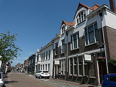
Markt, Oudenbosch
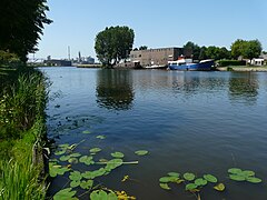
Oud Gastel

Hoeven, Sint Maartenspolder
Stampersgat


References[edit]
- ^ "Gemeentelijke indeling op 1 januari 1997" [Municipal divisions on 1 January 1997]. cbs.nl (in Dutch). CBS. Retrieved 28 May 2014.
- ^ "Burgemeester G.A.A.J. - Janssen" (in Dutch). Gemeente Halderberge. Archived from the original on 14 July 2014. Retrieved 28 May 2014.
- ^ "Kerncijfers wijken en buurten 2020" [Key figures for neighbourhoods 2020]. StatLine (in Dutch). CBS. 24 July 2020. Retrieved 19 September 2020.
- ^ "Postcodetool for 4731GJ". Actueel Hoogtebestand Nederland (in Dutch). Het Waterschapshuis. Retrieved 28 May 2014.
- ^ "Bevolkingsontwikkeling; regio per maand" [Population growth; regions per month]. CBS Statline (in Dutch). CBS. 1 January 2019. Retrieved 1 January 2019.
External links[edit]
 Media related to Halderberge at Wikimedia Commons
- Official website
Places adjacent to Halderberge | ||||||||||||||||
|---|---|---|---|---|---|---|---|---|---|---|---|---|---|---|---|---|
| ||||||||||||||||

This North Brabant location article is a stub. You can help Wikipedia by expanding it. |
No comments:
Post a Comment