Kosciusko, Mississippi
Kosciusko, Mississippi | |
|---|---|
 Welcome sign located on Mississippi Highway 12 | |
 Location of Kosciusko, Mississippi | |
| Coordinates: 33°3′29″N 89°35′18″W / 33.05806°N 89.58833°WCoordinates: 33°3′29″N 89°35′18″W / 33.05806°N 89.58833°W | |
| Country | United States |
| State | Mississippi |
| County | Attala |
| Named for | Tadeusz Kościuszko |
| Area | |
| • Total | 7.55 sq mi (19.56 km2) |
| • Land | 7.54 sq mi (19.53 km2) |
| • Water | 0.01 sq mi (0.02 km2) |
| Elevation | 479 ft (146 m) |
| Population (2020) | |
| • Total | 7,114 |
| • Density | 943.38/sq mi (364.22/km2) |
| Time zone | UTC-6 (Central (CST)) |
| • Summer (DST) | UTC-5 (CDT) |
| ZIP code | 39090 |
| Area code | 662 |
| FIPS code | 28-38320 |
| GNIS feature ID | 0672213 |
| Website | kosciusko |
Kosciusko /ˌkɒsiˈʌskoʊ/ is a city in Attala County, Mississippi, United States. The population was 7,402 at the 2010 census.[2] It is the county seat of Attala County.[3]
History[edit]
Shortly before the War of 1812, David Choate, a French trader along with his wife, a Choctaw, opened the Choate Stand, an inn along the Natchez Trace. They chose a location near the intersection of the trace and a cross path that led to the Creek Indian Nation, where there was a natural spring to provide fresh water, at the approximate location of the current town square. Journals from the war of 1812 indicate that Andrew Jackson received supplies at Choate Stand. In 1850, the Choate family was forcibly removed to Indian Territory in Oklahoma by the Indian Removal Act, signed by Andrew Jackson. In 2017 Kosciusko inaugurated an annual Return to Redbud Springs Festival to honor this history.[4]
The settlement was at one time named Red Bud Springs for a natural spring that was present in the city. Later, Redbud Springs was renamed Kosciusko, for General Tadeusz Kościuszko, a Polish officer who served with the Continental Army and assisted its military efforts during the American Revolution.[5] His name has been anglicized as 'Kosciusko'.
Throughout the 19th century, cotton was the predominant crop, and remains important in the area.[citation needed]
Kosciusko was the location of Magnolia Bible College from 1976 to 2008.
Geography[edit]
Kosciusko is located along the Yockanookany River, 62 mi (100 km) northeast of Jackson.
According to the United States Census Bureau, the city has a total area of 7.6 square miles (20 km2), of which 7.5 square miles (19 km2) is land and 0.13% is water.
Climate[edit]
The climate is characterized by hot, humid summers and generally mild to cool winters. According to the Köppen Climate Classification system, Kosciusko has a humid subtropical climate, abbreviated "Cfa" on climate maps.[6]
The data below are from the WRCC, compiled from 1893 to the time this chart was created (July 2018).[7]
| Climate data for Kosciusko, MS | |||||||||||||
|---|---|---|---|---|---|---|---|---|---|---|---|---|---|
| Month | Jan | Feb | Mar | Apr | May | Jun | Jul | Aug | Sep | Oct | Nov | Dec | Year |
| Record high °F (°C) | 85 (29) | 85 (29) | 92 (33) | 98 (37) | 102 (39) | 109 (43) | 108 (42) | 109 (43) | 109 (43) | 98 (37) | 89 (32) | 84 (29) | 109 (43) |
| Average high °F (°C) | 55.5 (13.1) | 58.8 (14.9) | 67.5 (19.7) | 75.5 (24.2) | 82.5 (28.1) | 89.4 (31.9) | 91.5 (33.1) | 91.6 (33.1) | 87.2 (30.7) | 77.3 (25.2) | 65.9 (18.8) | 57.0 (13.9) | 75.0 (23.9) |
| Average low °F (°C) | 33.6 (0.9) | 35.7 (2.1) | 42.8 (6.0) | 50.7 (10.4) | 58.8 (14.9) | 66.4 (19.1) | 69.4 (20.8) | 68.6 (20.3) | 62.6 (17.0) | 50.1 (10.1) | 40.8 (4.9) | 34.8 (1.6) | 51.2 (10.7) |
| Record low °F (°C) | −14 (−26) | −8 (−22) | 10 (−12) | 24 (−4) | 36 (2) | 41 (5) | 53 (12) | 50 (10) | 37 (3) | 20 (−7) | 12 (−11) | 0 (−18) | −14 (−26) |
| Average precipitation inches (mm) | 5.36 (136) | 5.27 (134) | 5.99 (152) | 5.35 (136) | 4.68 (119) | 3.66 (93) | 5.00 (127) | 3.76 (96) | 3.33 (85) | 3.19 (81) | 4.45 (113) | 5.41 (137) | 55.45 (1,409) |
| Average snowfall inches (cm) | 1.2 (3.0) | 0.3 (0.76) | 0.3 (0.76) | 0 (0) | 0 (0) | 0 (0) | 0 (0) | 0 (0) | 0 (0) | 0 (0) | 0 (0) | 0.4 (1.0) | 2.2 (5.52) |
| Source: https://wrcc.dri.edu/cgi-bin/cliMAIN.pl?ms4776 | |||||||||||||
Demographics[edit]
| Historical population | |||
|---|---|---|---|
| Census | Pop. | %± | |
| 1890 | 1,394 | — | |
| 1900 | 2,078 | 49.1% | |
| 1910 | 2,385 | 14.8% | |
| 1920 | 2,258 | −5.3% | |
| 1930 | 3,237 | 43.4% | |
| 1940 | 4,291 | 32.6% | |
| 1950 | 6,753 | 57.4% | |
| 1960 | 6,800 | 0.7% | |
| 1970 | 7,266 | 6.9% | |
| 1980 | 7,415 | 2.1% | |
| 1990 | 6,986 | −5.8% | |
| 2000 | 7,372 | 5.5% | |
| 2010 | 7,402 | 0.4% | |
| 2020 | 7,114 | −3.9% | |
| U.S. Decennial Census[8] | |||
2020 census[edit]
| Race | Num. | Perc. |
|---|---|---|
| White | 2,672 | 37.56% |
| Black or African American | 4,012 | 56.4% |
| Native American | 9 | 0.13% |
| Asian | 50 | 0.7% |
| Pacific Islander | 1 | 0.01% |
| Other/Mixed | 172 | 2.42% |
| Hispanic or Latino | 198 | 2.78% |
As of the 2020 United States Census, there were 7,114 people, 2,645 households, and 1,720 families residing in the city.
2000 census[edit]
As of the census[10] of 2000, there were 7,372 people, 2,885 households, and 1,906 families residing in the city. The population density was 977.8 people per square mile (377.5/km2). There were 3,174 housing units at an average density of 421.0 per square mile (162.5/km2). The racial makeup of the city was 53.66% White, 44.57% African American, 0.16% Native American, 0.46% Asian, 0.60% from other races, and 0.54% from two or more races. Hispanic or Latino of any race were 1.06% of the population.
There were 2,885 households, out of which 31.7% had children under the age of 18 living with them, 40.2% were married couples living together, 21.9% had a female householder with no husband present, and 33.9% were non-families. 31.2% of all households were made up of individuals, and 17.5% had someone living alone who was 65 years of age or older. The average household size was 2.43 and the average family size was 3.04.
In the city, the population was spread out, with 26.2% under the age of 18, 9.5% from 18 to 24, 23.9% from 25 to 44, 19.8% from 45 to 64, and 20.6% who were 65 years of age or older. The median age was 37 years. For every 100 females, there were 82.7 males. For every 100 females age 18 and over, there were 77.1 males.
The median income for a household in the city was $21,737, and the median income for a family was $29,000. Males had a median income of $27,423 versus $16,487 for females. The per capita income for the city was $13,478. About 20.9% of families and 24.2% of the population were below the poverty line, including 31.9% of those under age 18 and 20.1% of those age 65 or over.
Arts and culture[edit]
Kosciusko has hosted the Central Mississippi Fair for over 100 years.[11]
Kosciusko has been featured as part of the Mississippi Blues Trail since 2009.[12]
Education[edit]
The city of Kosciusko is served by the Kosciusko School District and includes Kosciusko Senior High School.
Notable people[edit]
- Dave Barnes, singer-songwriter and musician for Razor & Tie
- Billy Ray Bates, professional basketball player[13]
- Eva Webb Dodd, Anna Boyd Ellington, and Mary Comfort Leonard, founders of the Delta Gamma fraternity
- Clarence Harmon, former NFL running back for the Washington Redskins
- James Meredith, civil rights figure
- Charlie Musselwhite, blues harmonica player and band leader
- Jason Niles, lawyer, newspaper editor, and politician[14]
- Topher Payne, playwright[15]
- Blanche Colton Williams, author, editor, department head and professor of English literature, and pioneer in women's higher education.
- Oprah Winfrey, billionaire media entrepreneur and producer, actress, author, philanthropist, and former talk show host.
- Marc Woodard, former NFL linebacker for the Philadelphia Eagles
Gallery[edit]

Attala County Courthouse
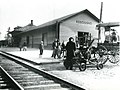
Illinois Central Depot in Kosciusko, 1920
.jpg)

References[edit]
- ^ "2020 U.S. Gazetteer Files". United States Census Bureau. Retrieved July 24, 2022.
- ^ "Geographic Identifiers: 2010 Demographic Profile Data (G001): Kosciusko city, Mississippi". U.S. Census Bureau, American Factfinder. Archived from the original on February 12, 2020. Retrieved June 19, 2013.
- ^ "Find a County". National Association of Counties. Archived from the original on 2011-05-31. Retrieved 2011-06-07.
- ^ Cathey, Mike (July 7, 2019). "Choate family -- Natchez Trace to Choate Prairie, Indian Territory". McAlester News-Capital. Retrieved 10 August 2021.
- ^ Gannett, Henry (1905). The Origin of Certain Place Names in the United States. Government Printing Office. p. 177.
- ^ "Kosciusko, Mississippi Köppen Climate Classification (Weatherbase)". Weatherbase. Retrieved 21 July 2015.
- ^ "KOSCIUSKO, MISSISSIPPI - Climate Summary". wrcc.dri.edu. Retrieved 2018-07-24.
- ^ "Census of Population and Housing". Census.gov. Retrieved June 4, 2015.
- ^ "Explore Census Data". data.census.gov. Retrieved 2021-12-08.
- ^ "U.S. Census website". United States Census Bureau. Retrieved 2008-01-31.
- ^ "Central Mississippi Fair". Retrieved 26 March 2019.
- ^ Dees, Leslie N. (January 23, 2009) Kosciusko to be featured on Blues Trail. The Star Herald
- ^ "NBA Players: Billy Ray Bates Profile and Basic Stats". Retrieved 28 February 2017.
- ^ "Early Attala Residents: Jason Niles". Attala County, Mississippi. MS Gen Web.
- ^ Topher Payne - Mississippi Arts & Entertainment Center Archived 2015-12-10 at the Wayback Machine. Msarts.org (2013-11-21). Retrieved on 2015-12-25.
External links[edit]
Municipalities and communities of Attala County, Mississippi, United States | ||
|---|---|---|
| Cities |  | |
| Towns | ||
| Unincorporated communities | ||
| Ghost towns | ||
| Indian reservation | ||
| Footnotes | ‡This populated place also has portions in an adjacent county or counties | |
| General | |
|---|---|
| National libraries | |
| Other | |
No comments:
Post a Comment