Kondalilla National Park
| Kondalilla Tops National Park Queensland | |
|---|---|
IUCN category II (national park) | |
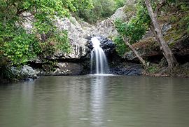
 Pool above Kondalilla Falls | |
| Nearest town or city | Mapleton, Queensland |
| Coordinates | 26°40′05″S 152°51′30″E / 26.66806°S 152.85833°ECoordinates: 26°40′05″S 152°51′30″E / 26.66806°S 152.85833°E |
| Established | 1945 |
| Area | 3.27 km2 (1.3 sq mi) |
| Managing authorities | Queensland Parks and Wildlife Service |
| Website | Kondalilla Tops National Park |
| See also | Protected areas of Queensland |
Kondalilla is a national park in the Blackall Range of South East Queensland, Australia, 91 km north of Brisbane. William Skene founded this area on his property while searching for lost cattle. He named it Bon Accord before giving it to the Queensland Government who, during the fifties, renamed it Kondalilla which is an Aboriginal word for running water. The area was first officially protected in 1906 as a recreational area, becoming a national park in 1945.[1][2]
Access is easiest by road from Flaxton, east of the park. There is a large picnic area where there are toilet facilities (non potable water). There are two tracks which lead to the upper falls swimming hole. A longer circuit track will take you to the bottom pool which is not suitable for swimming. Allow at least two hours for the circuit trip, which in some places is close to the cliff edge and is not fenced.
Camping in the park is not permitted.[1]
History[edit]
Bonyee festival[edit]
For countless generations, the Blackall Range has held spiritual significance for many Aboriginal people throughout South East Queensland.[3]
Abundant bunya pines growing throughout this area produced large nut crops, providing enough food for huge gatherings. When the nut crop peaked every three years, Kabi Kabi and neighbouring Wakka Wakka people hosted the Bonyee Festival. Many invited guests travelled great distances from coastal and inland areas to share food, songs and dances, arrange marriages, and other social interactions. A large grassy area near Baroon Pocket was an important gathering place.[3]
Pastoralists and timber-getters[edit]
From 1842 until 1860, the Blackall Range was part of a large reserve declared by Governor Gipps to protect the bunya pine food source for local Indigenous groups. It was illegal to settle or clear land where bunya pines occurred.[3]
When reserve status was rescinded, pastoralists and timber-getters came. In the 1880s, prized timber including red cedar, white beech, bunya pine, blackbutt and tallowwood was logged in the Blackall Range. The forest around Kondalilla was logged heavily and the ring-barked trees can still be seen today along the Picnic Creek circuit. Widespread clearing of the tableland forests ensued as settlement proceeded. However, some small areas were set aside for recreation.[3]
Recreational use[edit]
From the early 1900s, people began visiting this area for its "natural scenery, waterfalls and spectacular views".[3]
The first area to be protected was Kondalilla—in 1906 it became a recreational area, then a national park in 1945. Since then, reserves have been added across the Blackall Range to protect remnants of its natural communities. Kondalilla National Park (327ha) was linked to Obi Obi National Park in 1988. With other additions, including former State forest, the park has increased in size to 1591ha.[3]
Mapleton Falls (26ha) became a national park in 1973, after being a reserve for recreational and scenic purposes for 38 years. Mapleton National Park (10064ha) was gazetted on 28 March 2014 and is an amalgamation of Mapleton Forest Reserve and Delicia Road Conservation Park.[3]
Fauna[edit]
The park provides habitat for 107 bird species.[4] It is also home to the rare Pouched Frog.[1] The vulnerable plant species, Macadamia integrifolia, also known as the Bopple Nut, grows in the park.[4]
Flora[edit]
Protected within the park is remnant subtropical rainforest.[2] The park contains stands of piccabeen palms, pink ash, hoop pines and casuarinas as well as eucalypt forests and rainforest.[4] The stand of bunya pines is the most easterly in Australia.[2]
Walking Tracks[edit]
Picnic Creek Circuit (Class 2)
Distance: 1.7km
Time: Allow 45 minutes
Kondalilla Falls Circuit (Class 3)
Distance: 4.7km
Time: Allow 2hrs
See also[edit]
Sources[edit]
![]() This article incorporates text from a free content work. Licensed under CC-BY 4.0 License statement: Kondalilla National Park - Nature, culture and history, The State of Queensland (Department of Environment and Science),
This article incorporates text from a free content work. Licensed under CC-BY 4.0 License statement: Kondalilla National Park - Nature, culture and history, The State of Queensland (Department of Environment and Science),
References[edit]
- ^ a b c "About Kondalilla National Park". Department of Environment and Resource Management. 16 March 2010. Archived from the original on 11 April 2010. Retrieved 26 September 2010.
- ^ a b c Environmental Protection Agency (Queensland) (2000). Heritage Trails of the Great South East. State of Queensland. p. 133. ISBN 0-7345-1008-X.
- ^ a b c d e f g State of Queensland, Department of Environment and Science. "Kondalilla National Park - Nature, culture and history". Queensland Government - Parks and Forests. Retrieved 21 August 2019.
- ^ a b c Explore Queensland's National Parks. Prahran, Victoria: Explore Australia Publishing. 2008. p. 47. ISBN 978-1-74117-245-4.
External links[edit]
| Wikimedia Commons has media related to Kondalilla National Park. |

No comments:
Post a Comment