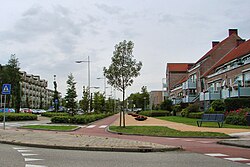
Castricum
Castricum | |
|---|---|
 Street in Castricum | |
 Location in North Holland | |
| Coordinates: 52°33′N 4°40′E / 52.550°N 4.667°ECoordinates: 52°33′N 4°40′E / 52.550°N 4.667°E | |
| Country | Netherlands |
| Province | North Holland |
| Government | |
| • Body | Municipal council |
| • Mayor | Toon Mans (VVD) |
| Area | |
| • Total | 60.40 km2 (23.32 sq mi) |
| • Land | 49.68 km2 (19.18 sq mi) |
| • Water | 10.72 km2 (4.14 sq mi) |
| Elevation | 0 m (0 ft) |
| Population (January 2019)[4] | |
| • Total | 35,772 |
| • Density | 720/km2 (1,900/sq mi) |
| Demonym(s) | Castricummer |
| Time zone | UTC+1 (CET) |
| • Summer (DST) | UTC+2 (CEST) |
| Postcode | 1489, 1900–1906, 1920–1921 |
| Area code | 0251 |
| Website | www |
Castricum (Dutch pronunciation: [ˈkɑstrikʏm] (![]() listen)) is a municipality and a town in the province of North Holland in the Netherlands.
listen)) is a municipality and a town in the province of North Holland in the Netherlands.
Castricum is a seaside town in the province of North Holland. It draws in a fair share of tourists who mainly come to visit the beach and nearby dune landscape. In Castricum's vicinity there is also the lake of Alkmaar-Uitgeest which offers various sailing and windsurfing opportunities.
History[edit]
On 6 October 1799, a Franco-Dutch army under Guillaume Brune defeated an Anglo-Russian army under Ralph Abercromby and the Duke of York in the Battle of Castricum.
The municipalities of Akersloot and Limmen merged into the municipality of Castricum on 1 January 2002.
Population centres[edit]
The municipality of Castricum is made up of the following towns, villages and/or districts: Castricum, Akersloot, Bakkum, De Woude, Limmen.
Transportation[edit]
The town is served by Castricum railway station. From here there are 4 trains an hour to Amsterdam, with a journey time of 28 minutes.
Local government[edit]
The municipal council of Castricum consists of 25 seats, which are divided as follows:
- VVD - 5 seats
- Castricum Kernen Gezond (CKenG) - 3 seats
- GDB[1] -2 seats
- PvdA - 1 seat
- CDA - 4 seats
- Green party- 3 seats
- D66 - 2 seats
- De Vrije Lijst - 2 seats
- Forza - 1 seat
- lijst Kooter - 1 seat
- lijst van Schoonhoven - 1 seat
At the moment, the college van burgemeester en wethouders (the municipal board) is formed by the VVD, CDA and de Vrije Lijst.
Notable people[edit]
- Willem Jacobszoon Coster (1590 in Akersloot – 1640) Dutch colonial Governor of Zeylan in 1640
- John Ton (1826 in Akersloot - 1896) an American abolitionist active in the Underground Railroad in Illinois.
- Willem Schermerhorn (1894 in Akersloot – 1977) a Dutch politician, Prime Minister of the Netherlands 1945/1946
- Abraham Louis Schneiders (1925 in Castricum - 2020) a Dutch diplomat and writer[5]
- Jan Gmelich Meijling (1936 in Heemstede – 2012) a Dutch politician, naval officer and Mayor of Castricum from 1978 to 1985
- Theo van den Boogaard (born 1948 in Castricum) a Dutch cartoonist
- Henk Jaap Beentje (born 1951 in Bakkum) a Dutch botanist, works at the Royal Botanic Gardens, Kew
- Sefa Jeroen Vlaarkamp (2000 in Alkmaar) a Dutch frenchcore musician
Sport[edit]
- Arjan de Zeeuw (born 1970 in Castricum) a retired Dutch footballer with 553 club caps
- Eddy Putter (born 1982 in Akersloot) a Dutch football player with over 200 club caps
- Kees Luijckx (born 1986 in Beverwijk) a Dutch footballer with over 270 club caps
See also[edit]
- Huis van Hilde, provincial archaeology centre in Castricum
Gallery[edit]
References[edit]
- ^ "Burgemeester Toon Mans" [Mayor Toon Mans] (in Dutch). Gemeente Castricum. Retrieved 26 February 2014.
- ^ "Kerncijfers wijken en buurten 2020" [Key figures for neighbourhoods 2020]. StatLine (in Dutch). CBS. 24 July 2020. Retrieved 19 September 2020.
- ^ "Postcodetool for 1902CA". Actueel Hoogtebestand Nederland (in Dutch). Het Waterschapshuis. Retrieved 26 February 2014.
- ^ "Bevolkingsontwikkeling; regio per maand" [Population growth; regions per month]. CBS Statline (in Dutch). CBS. 1 January 2019. Retrieved 1 January 2019.
- ^ Nico Keuning (1986). "Tirade. Year 30. #301-307". Digital Library for Dutch Literature (in Dutch). Retrieved 6 July 2020.
External links[edit]
 Media related to Castricum at Wikimedia Commons
- Official website


No comments:
Post a Comment