Obdam
Obdam | |
|---|---|
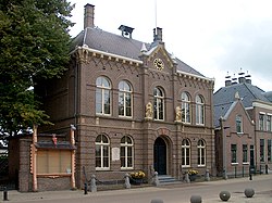
 Former town hall | |
 | |
| Coordinates: 52°40′28″N 4°54′14″E / 52.67444°N 4.90389°ECoordinates: 52°40′28″N 4°54′14″E / 52.67444°N 4.90389°E | |
| Country | Kingdom of the Netherlands |
| Constituent country | |
| Province | North Holland |
| Municipality | Koggenland |
| Area | |
| • Total | 20.95 km2 (8.09 sq mi) |
| • Land | 20.64 km2 (7.97 sq mi) |
| • Water | 0.31 km2 (0.12 sq mi) |
| Population (2005) | |
| • Total | 6,800 |
| • Density | 329/km2 (850/sq mi) |
| Time zone | UTC+1 (CET) |
| • Summer (DST) | UTC+2 (CEST) |
| Website | www |
Obdam (Dutch pronunciation: [ɔbˈdɑm] (![]() listen)) is a former municipality and a town in the Netherlands, in the province of North Holland and the region of West-Frisia. The municipality ceased to exist on 1 January 2007 when it merged with Wester-Koggenland to form the new municipality of Koggenland.
listen)) is a former municipality and a town in the Netherlands, in the province of North Holland and the region of West-Frisia. The municipality ceased to exist on 1 January 2007 when it merged with Wester-Koggenland to form the new municipality of Koggenland.
Population centres[edit]
The area of the former municipality of Obdam consists of the following cities, towns, villages and/or districts: Berkmeer, Hensbroek, Obdam, Wogmeer (partly).
Train services[edit]
These services currently (2014), depart for Hoorn, from platform 1, at xx.00 and xx.30 minutes past the hour. Travel time to Amsterdam is just 55 minutes.
Chronology[edit]
- 1503 - The van Duvenvoorde family becomes the Lordship of the town.
- 1610 - Birth of Jacob, Baron van Wassenaer, Lord of Obdam; Son of Jacob van Duvenvoorde van Wassenaer
- 1620 - Jacob van Duvenvoorde starts using the van Wassenaer family name and becomes Jacob van Duvenvoorde van Wassenaer
- 1665 - Jacob, Baron van Wassenaer, Lord Of Obdam dies during a sea battle with the English while being the captain of a Dutch vessel.
- 1979 - Founding of the new municipality, including the towns of Hensbroek and Wogmeer.
- 2007 - The Obdam municipal merges into municipal Koggenland
Jacob, Baron van Wassenaer, Lord of Obdam by Abraham Evertsz. van Westerveld
Local government[edit]
Before the merger, the last municipal council of Obdam consisted of 13 seats, which were divided as follows:
References[edit]
| Wikimedia Commons has media related to Obdam. |
- Statistics are taken from the SDU Staatscourant


No comments:
Post a Comment