Claremont Isles National Park
This article needs additional citations for verification. (August 2013) (Learn how and when to remove this template message) |
| Claremont Isles National Park Queensland | |
|---|---|
IUCN category II (national park) | |
| Coordinates | 13°54′40″S 143°50′02″E / 13.91111°S 143.83389°ECoordinates: 13°54′40″S 143°50′02″E / 13.91111°S 143.83389°E |
| Established | 1989 |
| Area | 0.41 km2 (0.16 sq mi) |
| Managing authorities | Queensland Parks and Wildlife Service |
| See also | Protected areas of Queensland |
Claremont Isles is a national park located in Queensland, Australia, 1783 km northwest of Brisbane. Established in 1989, the isles are managed by the Queensland Parks and Wildlife Service.
The isles constitute an important breeding and roosting habitat for a variety of birds, specially seabirds. The habitat consists of coral reefs and swaths of offshore seagrass. This makes it a unique habitat for the birds. To preserve the area, going ashore is prohibited.[1]
Wildlife[edit]
The isles provided habitat to a variety of birds and animals.
Birds[edit]
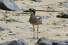
There are three islands in the Claremont Isles National Park: Fife, Pelican and Burkitt islands. All three islands have breeding populations of terns. Burkitt Island is an important breeding ground for the pied imperial pigeon. Migratory species such as the beach stone-curlew also flock to the island's extensive sand flats and lagoons. Australian terns lend the Pelican Island their name and Fife Island is famous for its population of wedge-tailed shearwaters.[2]
See also[edit]
References[edit]
- ^ "Claremont Isles National Park". The State of Queensland (Department of National Parks, Recreation, Sport and Racing). Retrieved 5 July 2013.
- ^ "About Claremont Isles". The State of Queensland (Department of National Parks, Recreation, Sport and Racing). Retrieved 5 July 2013.
| This Queensland protected areas related article is a stub. You can help Wikipedia by expanding it. |


No comments:
Post a Comment